A noticeable increase in the pace of unstable weather conditions on Thursday night and Friday, and fears of torrential floods in several areas
Arab Weather - Weather experts at the Arab Weather Center said that the latest data from computer modeling shows an intensification of atmospheric instability at the end of the week, accompanied by showers in several areas. It will intensify during the hours of Thursday/Friday night and Friday, when the upper air depression passes and a clear intensification of the instability occurs, leading to the proliferation of cumulus clouds with showers of heavy rain in different areas, concentrated in the central and southern regions, and sometimes very heavy and accompanied by strong thunderstorms and lightning, and showers of heavy accumulated hail.
The state of atmospheric instability will continue on Thursday, concentrated in the south of the country, while the chances of rain will temporarily weaken in the rest of the regions.
In detail, temperatures rise significantly and become warmer than their usual rates for this time of year on Thursday, and the weather is moderate in most parts of the country, including the capital, Baghdad. The state of atmospheric instability continues, but it is concentrated in the southern parts, where clouds multiply at different altitudes, and showers of rain fall in scattered areas, sometimes heavy in some areas. As for the winds, they are moderate easterly, but they may sometimes be active and stir up dust and dirt.
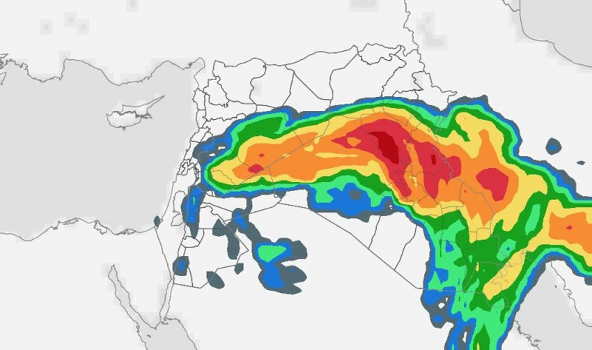
The upper air depression will pass and there will be a clear increase in the intensity of the instability during the hours of Thursday/Friday night and Friday dawn and day.
During the night hours, Thursday/Friday night, and with the passage of the low pressure system in the upper atmosphere, the state of instability is expected to intensify, as cumulus clouds multiply and heavy rain showers are expected to fall on several regions, especially central and southern Iraq, accompanied by severe thunderstorms and heavy hail showers.
On Friday, the weather instability will continue, temperatures will drop slightly, and the weather will be moderate in most areas. The weather instability will continue in several areas, with cumulus clouds multiplying and heavy showers of rain, sometimes very heavy and accompanied by thunderstorms.
Arab Weather Recommendations:
- Beware of the risks of flash floods and torrential rains, especially in the south.
- Beware of the risks of rising water levels, especially in the southern regions.
- Stay away from valleys, streams and ravines.
- Beware of the risks of increasing dust levels in the atmosphere and their impact on patients with respiratory diseases, eyes, and horizontal vision, especially during the passage of thunderclouds.
- It warns of soil and rock drifts on roads and slopes.
- Take shelter indoors during thunderstorms.
God knows best.
Browse on the official website