Secondary consequences of a low pressure system affecting Egypt on Thursday, and polar winds affecting the country starting on Saturday
Arab Weather - Weather maps indicate that Egypt will be affected, God willing, on Thursday by secondary consequences of a distant low pressure system affecting the Levant, and its effects will extend to the Republic in the form of a decrease in temperatures and a noticeable activity in wind speed, especially in the northern coastal areas, which will cause waves to become disturbed. Cloud cover will also increase and there will be a chance for showers of rain to fall on some northern coastal areas, extending to parts of northern Lower Egypt and neighborhoods of Greater Cairo.
Temperatures will drop further on Friday, God willing, and relatively cold weather will prevail in most areas of the north of the country, with large amounts of low clouds appearing that may cause rain in some areas. Northwesterly winds will continue to be active at intervals, God willing, while the general characteristic of the weather will remain cold during the night hours.
Very cold polar winds will reach Egypt starting Saturday, causing a drop in temperatures and strong winds.
The results of computer map analyses at the Arab Weather Regional Center indicate that Egypt will be affected, God willing, starting from Saturday, February 22, for several days, by the infiltration of very cold polar winds coming from eastern Europe towards the Mediterranean Sea, reaching the Republic.
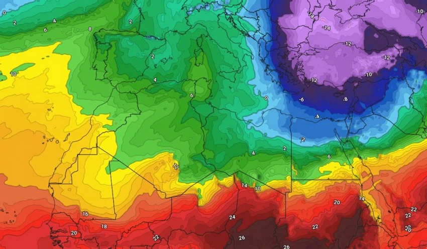
These polar winds cause a drop in both maximum and minimum temperatures, especially in the northern regions of the country. The feeling of cold weather is compounded by the presence of large amounts of clouds that block the sun's rays, and coincides with a significant activity in the speed of surface winds.
Northwesterly winds will blow, active to strong and very cold, over the country, causing severe disturbance in the sea waves, especially in the Mediterranean. They will also stir up sand in large quantities in the interior regions and desert roads, especially in central and southern Upper Egypt, God willing.
And God knows best.
Browse on the official website