هام .. الأرصاد العمانية تتوقع تطور منخفض بحر العرب إلى عاصفة مدارية خلال الـ 24 ساعة القادمة

2019-09-22 2019-09-22T21:17:29Z
سنان خلف
سنان خلف
محرر أخبار جوية- قسم التواصل الاجتماعي

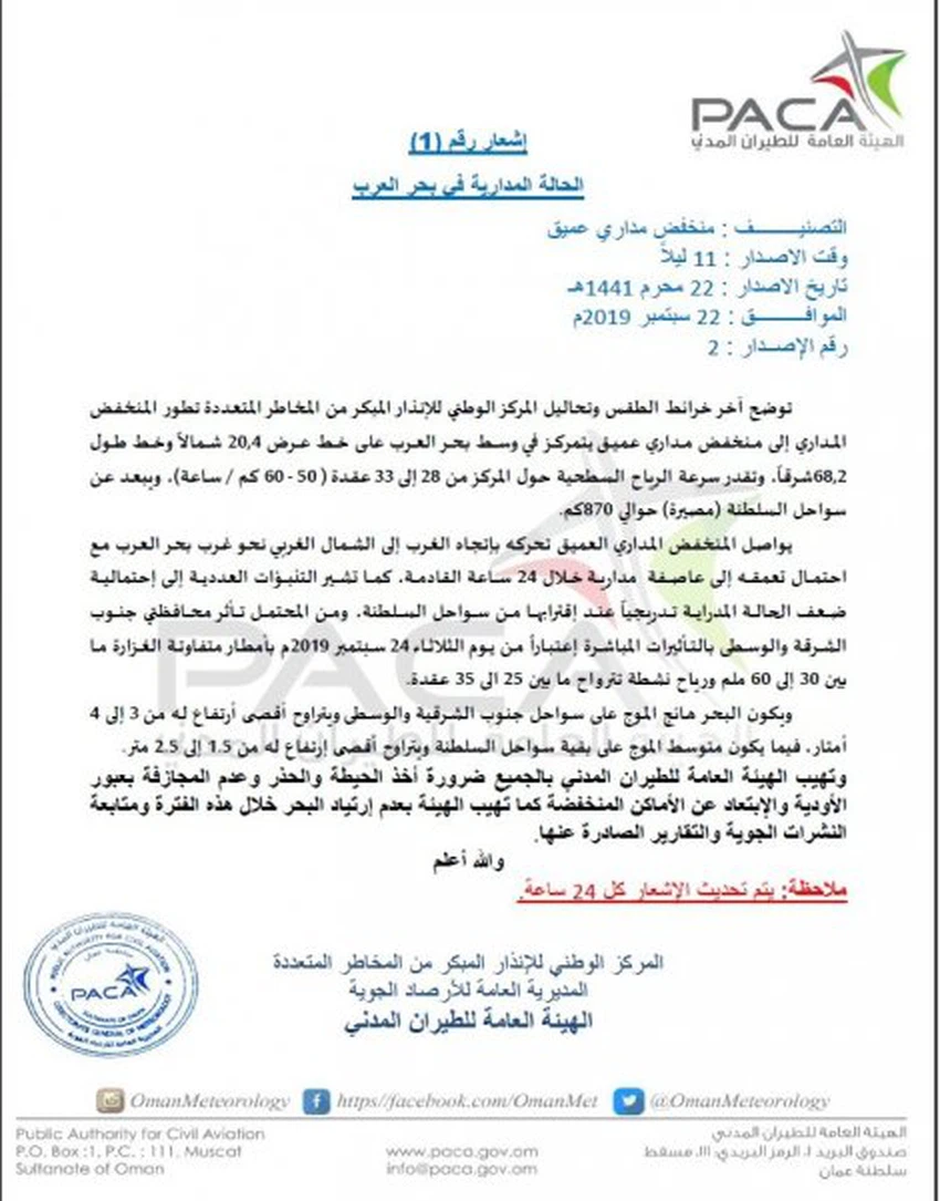
طقس العرب - سنان خلف - أصدرت الهيئة العامة للأرصاد الجوية في سلطنة عُمان تقريراً جديداً يتضمن آخر تطورات الحالة المدارية في بحر العرب، وجاء في التقرير الإعلان عن تطور المنخفض المداري إلى منخفض مداري عميق، كما أشار التقرير إلى احتمالة تطوره إلى عاصفة مدارية خلال الـ 24 ساعة القادمة، وفيما يلي نص التقرير:


This article was written originally in Arabic and is translated using a 3rd party automated service. ArabiaWeather is not responsible for any grammatical errors whatsoever.
See More
Related News
Arabian Gulf: Forty-degree temperatures, thunderstorms, and active winds that will stir up dust and sand in some areas over the coming days.

Arabian Gulf: Forty-degree temperatures, thunderstorms, and active winds that will stir up dust and sand in some areas over the coming days.

A very cold air mass of polar origin is located in eastern Europe, pushing its cold winds to the Levant.

A very cold air mass of polar origin is located in eastern Europe, pushing its cold winds to the Levant.

Bringing spring snow to mountain peaks, a cold air mass is affecting the eastern Mediterranean and the Levant, accompanied by radical changes in the weather (details)

Bringing spring snow to mountain peaks, a cold air mass is affecting the eastern Mediterranean and the Levant, accompanied by radical changes in the weather (details)

Weather conditions and sky conditions in the Arab world at the time of observing the crescent of Shawwal 1446 AH

Weather conditions and sky conditions in the Arab world at the time of observing the crescent of Shawwal 1446 AH