أعلى هبات رياح مسجلة حتى الساعة 2:30

2019-01-06 2019-01-06T14:12:55Z
وداد السعودي
وداد السعودي
محرر أخبار جوية- قسم التواصل الاجتماعي

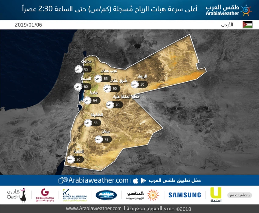
طقس العرب- تشهد أجزاء واسعة من المملكة الآن نشاطًا ملحوظًا على سرعة الرياح بسبب تأثر المملكة بمنخفض جوي من الدرجة الثانية، وفقا لمقياس طقس العرب للمنخفضات الجوية.


وتعمل هذه الرياح النشطة على إثارة الغبار والاتربة التي تعمل على تدني مدى الرؤية الأفقية.


وتاليًا سرعة هبات الرياح  بحسب المحطات المتوفرة حالياً، بينما لم تصلنا  القراءة لباقي المناطقحتى الآن


This article was written originally in Arabic and is translated using a 3rd party automated service. ArabiaWeather is not responsible for any grammatical errors whatsoever.
Plus
Related News
Photo of the day | For the first time... snow falls on the mountains of Cyprus in May

Photo of the day | For the first time... snow falls on the mountains of Cyprus in May

The cold wave intensified tonight, and temperatures reached winter levels.

The cold wave intensified tonight, and temperatures reached winter levels.

The low-pressure system deepened, bringing torrential rain, thunderstorms, and hail to Syria and Lebanon.

The low-pressure system deepened, bringing torrential rain, thunderstorms, and hail to Syria and Lebanon.

A relatively cold air mass is affecting the Kingdom, accompanied by active winds and chances of rain, especially in the north of the Kingdom.

A relatively cold air mass is affecting the Kingdom, accompanied by active winds and chances of rain, especially in the north of the Kingdom.