بالانفوجرافيك .. ملخص المنخفض الجوي المتوقع يوم الأربعاء 16 يناير 2019

2019-01-15 2019-01-15T20:35:20Z
أريج الدجاني
أريج الدجاني
محرر أخبار جوية - قسم التواصل الاجتماعي

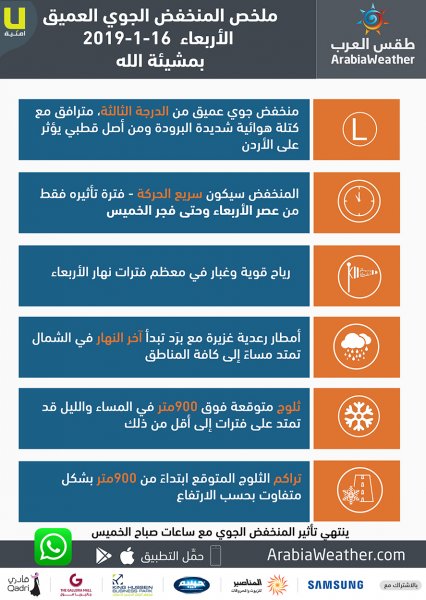
موقع "طقس العرب"- تتأثر المملكة يوم الأربعاء بمنخفض جوي من الدرجة "الثالثة" مصحوب بجبهة ثلجية إعتباراً من ساعات ما بعد العصر والليل الأولى وحتى ساعات منتصف الليل.


ويسبق عبور هذه الجبهة، هبوب لرياح قوية تصل سرعتها 100كم/ساعة ، مترافقة بموجات من الغبار القادمة عبر الأراضي المصرية.


وتالياً ملخص الطقس خلال المنخفض الجوي المتوقع يوم الأربعاء 16 يناير 2019


ملخص المنخفض الجوي 2019/16/1


This article was written originally in Arabic and is translated using a 3rd party automated service. ArabiaWeather is not responsible for any grammatical errors whatsoever.
See More
Related News
Jordan: Low clouds and humid, cool nights expected in the coming days

Jordan: Low clouds and humid, cool nights expected in the coming days

Autumn harbingers are looming: low cloud cover and rain on the Levant coast.

Autumn harbingers are looming: low cloud cover and rain on the Levant coast.

The star Suhail will be visible in the Jordanian sky with the naked eye after September 15th.

The star Suhail will be visible in the Jordanian sky with the naked eye after September 15th.

A massive Atlantic storm is developing and weather fluctuations are being observed in the Arctic, heralding the approach of autumn in the Northern Hemisphere.

A massive Atlantic storm is developing and weather fluctuations are being observed in the Arctic, heralding the approach of autumn in the Northern Hemisphere.