تنبيه متقدم | موجة من الغبار الكثيف يُتوقع تأثيرها على مدينة جدة نهار الأحد

2019-01-26 2019-01-26T13:50:42Z
سنان خلف
سنان خلف
محرر أخبار جوية- قسم التواصل الاجتماعي

طقس العرب - سنان خلف - نبه كادر التنبؤآت في "مركز طقس العرب الإقليمي" من تأثر مدينة جدة يوم الأحد بموجة من الغبار الكثيف،  كنتيجة لهبوب رياح جنوبية إلى جنوبية شرقية نشطة السرعة مع هبات قوية، تعمل على اثارة الأتربة والغبار بكثافة عالية.


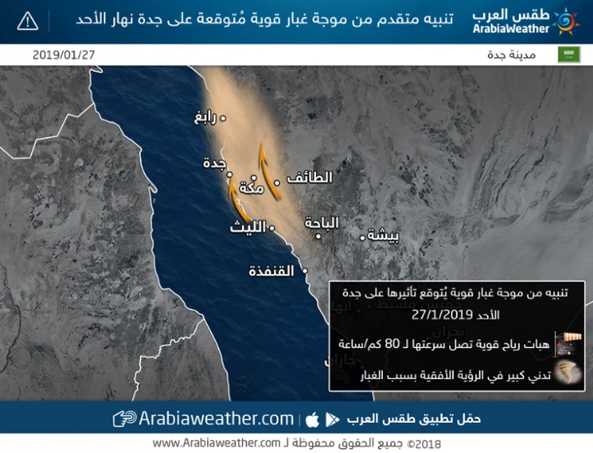
ويتوقع ان يصل معدل سرعة الرياح الشرقية الى 40 كم/ ساعة مع هبات قوية قد تتجاوز 75 كم/ساعة مثيرة للغبار الكثيف أحيانا والمؤدي لانخفاض مدى الرؤية الافقية بشكل كبير.


ويأتي نشاط هذه الرياح كنتيجة لتشكل منخفض جوي سطحي شمال البحر الأحمر ، يفعل اقتراب كتلة هوائية باردة من الشمال، ما يؤدي الى نشاط الرياح الجنوبية المثيرة للغبار والأتربة.


هذه الأحوال الجوية تستوجب التنبيه من :

1- تدني مدى الرؤية الافقية نتيجة الغبار والعواصف الرملية.

2- خطر شدة سرعة الرياح والتي تقترب هباتها من حاجز 75 /ساعة.

This article was written originally in Arabic and is translated using a 3rd party automated service. ArabiaWeather is not responsible for any grammatical errors whatsoever.
See More
Related News
Urgent - Asir | Meteorology raises warning level to red due to a weather condition including thunderstorms

Urgent - Asir | Meteorology raises warning level to red due to a weather condition including thunderstorms

Heavy rain accompanied by lightning and hail is expected in several regions of the Arab world during the first week of May.

Heavy rain accompanied by lightning and hail is expected in several regions of the Arab world during the first week of May.

A very cold polar air mass reaches Türkiye, with potential consequences for the region.

A very cold polar air mass reaches Türkiye, with potential consequences for the region.

A regional cold wave will affect eight Arab countries starting Sunday night/Monday morning and continuing until midweek.

A regional cold wave will affect eight Arab countries starting Sunday night/Monday morning and continuing until midweek.