Fohen winds ignite the skies of Iraq, and temperatures exceed 50 degrees Celsius in several regions.

Arab Weather - Numerical computer models at the Arab Weather Center sense that a very hot air mass will be centered over Iraq and will loom over most of the country, causing a clear intensification of the heat wave on Saturday, Sunday and Monday, as temperatures will rise further, far exceeding what they are supposed to be. The most appropriate description of the weather at that time will be as blazing in Baghdad and all regions of Iraq, as maximum temperatures will be between 49-51 degrees Celsius in the capital Baghdad and the northern regions, while they will reach the threshold of 50-52 degrees Celsius in the southern and desert regions, including the city of Basra. These are record values that are expected to be recorded for the first time this year, God willing.
Hot nights await Iraq, and low temperatures are recorded in Arab capitals at the height of the day.
God willing, night temperatures are expected to rise significantly during the heat wave period, especially at the end of the week, making the weather hot and humid during the night hours in various parts of Iraq. Minimum temperatures (the lowest temperature during the day) will be very high, reaching approximately 33-34 degrees Celsius, which are values recorded during the peak of the day in the capitals of the Levant sometimes.
Important recommendations from Arab Weather during the heat wave and dusty weather:
Avoid prolonged and direct exposure to sunlight.
Drink adequate amounts of fluids and moisturizers regularly.
Do not leave pressurized containers or any flammable materials inside closed vehicles in the sun.
Do not leave children inside closed vehicles, even for a short period.
Beware of the risk of increased dust levels and their impact on patients with respiratory and eye diseases and horizontal visibility.
Wear loose, light-colored clothing and hats.
For those interested and specialists: The heat dome and the foehn winds are two sides of the same coin and they both promote the rise in temperature.
A heat dome is a climatic phenomenon that results from a high-pressure area in the upper atmosphere. It heats the air in the lower atmosphere due to a dynamic process called "heating under pressure." As the air in a specific area is compressed under the influence of a high-pressure area in the upper atmosphere, a hot surface air mass is created, the intensity of which varies depending on the area, the intensity of the high-pressure area, and the period of its formation during the year.
The high air traps the hot air like a lid on a boiling pot. As the hot air expands vertically in the atmosphere, the high pressure pushes it back toward the ground. The air is compressed again beneath the high pressure area, causing it to gain more heat. This is known scientifically as heating under pressure.
The Foehn phenomenon, or Foehn winds, is simply the descent of winds from high mountain peaks towards lower slopes and valleys, where the air is rapidly heated due to this movement, as shown in the following diagram:
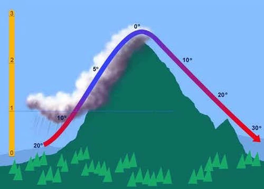
As a quick mathematical calculation in meteorology, the air cools by 1 degree Celsius for every 150 meters we rise above sea level, but it warms by 1.5 degrees Celsius for every 150 meters we descend from sea level. Suppose we are in area (A) at an altitude of 0 meters above sea level and the air temperature is 40 degrees Celsius. There is a mountain 1000 meters high and we want to know what the temperature of the same air would be if it moved from point (A) to point (B) behind the mountain at an altitude of 0 meters, the calculation would be as follows:
40 - (150/1000)*1 + (150/1000)*1.5 = 43.34 degrees Celsius,
That is, the air temperature rose by 3.34°C at point (B) due to the process of descending the mountain.
And God knows best.


Arabia Weather App
Download the app to receive weather notifications and more..